Küre Mountains National Park—one of Europe’s 100 forest hotspots
On the western Black Sea coast of Turkey, between the Bartın and Kızılırmak rivers, the Küre Mountains stretch for 300 kilometers—the wettest and most forested range in the Western Black Sea region. In 2000, the best part of these mountains was designated as the Küre Mountains National Park (Küre Dağları Millî Parkı). The park covers an area of about 80,000 hectares, with a core zone of 37,753 hectares; the average elevation is 500 meters. The Küre Mountains National Park has been recognized by the WWF as one of Europe’s 100 forest hotspots requiring urgent protection, as well as the only one of Turkey’s eight critical natural areas to be included in the European list of the 20 most vulnerable natural territories. Bears and lynxes live here, 157 endemic species bloom, and the canyons plunge hundreds of meters into the depths.
History and Origin of the Küre Mountains National Park
The international conservation community’s interest in the Küre Mountains emerged as early as 1988, when the WWF included this area among its conservation priorities. At that time, work began on developing a conservation plan for the region. In the 1990s, the activities of mining and quarrying enterprises, as well as the clearing of forests for agricultural land, caused serious damage to the region—it was precisely this threat of destruction that led to the intensification of conservation efforts.
From 1998 to 2000, the Turkish Ministry of Forestry, with support from UNDP and FAO, implemented a project on national park management and biodiversity conservation. This resulted in the official establishment of Küre Dağları National Park on July 7, 2000. The park covers the districts of Pınarbaşı, Cide, Şenpazar, Azdavay, Kurucaşile, Ulus, and Amasra in the provinces of Kastamonu and Bartın. That same year, the concept of a buffer zone around protected areas was officially added to Turkey’s agenda.
In 2001, an Ecotourism Center opened in Pınarbaşı, where 20 local nature guides were trained. In 2002, ecotourism maps were published, and from 2001 to 2006, campaigns promoting sustainable forest use were launched among local communities. Ecotourism has created new jobs—especially for women, foresters, and unemployed youth. In April 2012, the park received certification from PAN Parks—the Network of Protected Areas in Europe.
Natural Areas and What to See
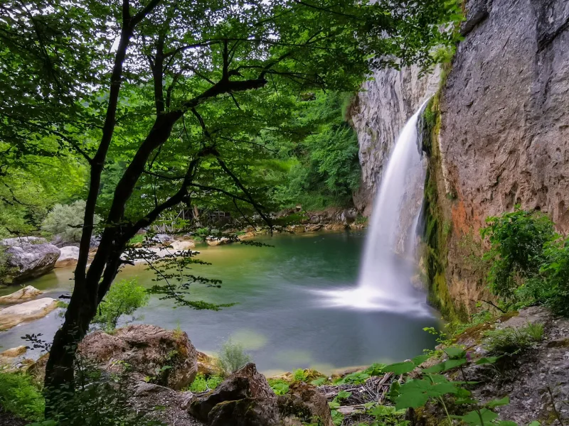
The key word for understanding the Küre Mountains is “humidity.” The western part of the Black Sea Mountains receives one of the highest annual precipitation amounts in Turkey; combined with the limestone terrain, this has created an ecosystem of canyons, caves, and relict forests.
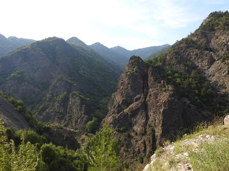
Canyons: Horma, Valla, Çatak, Aydos
The park’s four main canyons—Horma, Valla, Çatak, and Aydos—form a unique ecosystem. The Valla Canyon is distinguished by walls over 1,000 meters high and strong storm winds, making it one of the most inaccessible places. The canyons cut through the karst landscape, creating narrow corridors with vertical limestone walls, at the base of which a mountain stream flows. Canyoning here requires special equipment and an experienced guide.
Ilgarini Cave
Ilgarini Cave is one of the deepest caves in Turkey. Its entrance is enormous, with a total length of 850 meters and a depth of 250 meters. The final two hours of the approach to the cave pass through a steep, damp, untouched forest. Visits are only possible with a local guide. At the entrance, there are preserved ruins of a small settlement (about 10 houses), presumably dating back to the Byzantine period, and water cisterns.
Forests: Five Altitudinal Zones
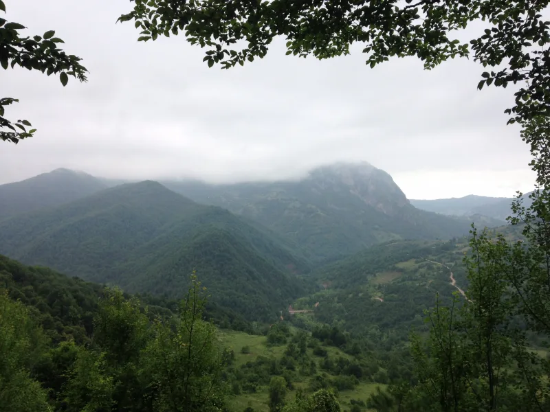
The Black Sea forests of Kyure are divided into five altitudinal zones. Near the coast—olive trees, strawberry trees, chestnuts, wild strawberries, and Crimean pine. Higher up—mixed forests dominated by fir, beech, and maple. The higher you go, the more frequently you encounter pristine old-growth stands—these are what are referred to as “old-growth forest formations.” For Russian-speaking travelers: a similar multi-tiered forest structure is familiar from the Caucasus, but Kyure’s flora is distinct and richer in endemic species.
Fauna and Ecotourism
The park is home to 48 of Turkey’s 160 mammal species: brown bear, roe deer, wild boar, otter, wolf (traces have recently been recorded again), and lynx. In 1999, red deer were reintroduced here—a species that had completely disappeared from Anatolia in the 1950s. Available active tourism activities: wildlife watching, hiking trails (trekking and hiking), horseback riding, mountain biking, caving, canyoning, and rock climbing.
Interesting facts and legends
- The Küre Mountains are the only one of Turkey’s eight critical natural areas included in the European list of the 20 most endangered natural areas, compiled in the 1990s.
- In 1999, red deer were introduced to the park from Bolu—a species that had disappeared from the wild in Anatolia in the 1950s; today, the population is recovering.
- In the Küre Mountains, 157 species of endemic plants have been recorded, 59 of which are listed on the Red List; a new species—Abant Kazgagası—was recently identified, bringing the total number of endemics to 158.
- The 250-meter-deep Ylgari Cave is one of the deepest in Turkey; at its entrance, ruins of a Byzantine-period settlement remain, though they have been damaged by treasure hunters.
- The park received PAN Parks certification in 2012—the first in Turkey—demonstrating compliance with international standards for the management of protected areas.
How to get there
Küre Mountains National Park covers several districts of the provinces of Kastamonu and Bartın. The nearest major airports are Kastamonu (KFS) and Zonguldak (ONQ); both are approximately a 1–1.5-hour flight from Istanbul. From Istanbul, the bus ride to Kastamonu takes about 4 hours, and to Bartın about 4.5 hours. Entry to the park is possible through several gates; the most convenient routes are via Pınarbaşı (the ecotourism center) or via Amasra.
Amasra—a picturesque Black Sea town with a port, a historic fortress, and several hotels—is an ideal base for day trips to the park. It is about 50 km from Kastamonu to the park entrance in the Pınarbaşı area. A guide is required for most routes (especially canyoning and Yılgarini): book in advance through the Pınarbaşı Ecotourism Center or local travel agencies in Kastamonu.
Tips for travelers
The best time to visit the park is May–October. In May, the mountain meadows are in bloom and the rivers are full; June–August offers comfortable weather for trekking; in autumn (September–October), the forests turn golden and crimson—one of the best sights in the Black Sea region. In winter, some roads are impassable due to snow.
For hiking trails, you’ll need hiking boots with good traction: the forest and canyons are often damp. For canyoning and caving, you’ll need specialized gear, which can be rented in Pınarbaşı or through guides. Cell service in the valleys is unreliable—offline maps are a must. There is no regular public transportation from Kastamonu to the park—you’ll need a car or an organized tour. In the villages around the park, tourists are welcomed at family-run guesthouses (pansiyon)—a traditional format for Turkish ecotourism featuring home-cooked meals and local knowledge.
The park pairs well with a visit to Amasra (UNESCO, historic fortress, and beaches) and İnebolu (ancient Abonotich). Küre Mountains National Park — for those who aren’t looking for beaches and ruins in Turkey, but for a real wild forest where brown bears leave tracks in the mud and a canyon opens up like a sudden chasm around a bend in the trail.